Need Help with Your Ongoing Projects?
Have questions? Connect with us today! Explore how our innovative technology can optimize your projects and drive success. Together, we’ll take your business to the next level!

Client Name
AR Mavericks

C#.NET
AutoDesk Civil 3D
Engineering
The GeoTag add-on is a specialized extension designed for Civil 3D, offering a unique capability for placing georeferenced tags, also known as blocks, within a georeferenced drawing. During the guided placement process, users input particular attribute data, such as text and hyperlinks, during block insertion. Most importantly, the add-on automatically sends the attributes of the newly placed block as well as the geolocation information to the AR Mavericks online cloud server. In essence, the GeoTag add-on enhances Civil 3D by streamlining the placement of georeferenced tags, and its integration with the AR Mavericks online cloud server via API ensures a smooth transfer of data for further processing or analysis.
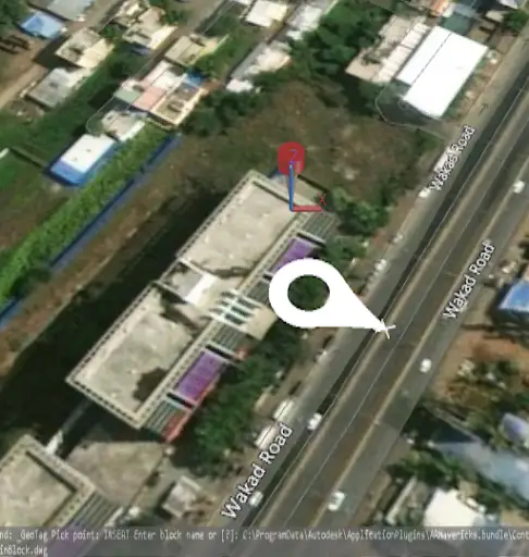
Fig1. Tag Insertion

Fig2. Adding the Attribute to the Tag
“ProtoTech Solutions is a critical asset for my small, bootstrapped startup. When you are using agencies and freelancers for major development projects, you quickly learn there are big differences in the quality of available services. With ProtoTech, starting with their initial proposal, it was evident they are a best-in-class organization. They delivered on every point of the proposal on time and showed an incredible depth of expertise in their domain. I consider them a valuable partner, not just a vendor.”
Founder and CEO,AR Mavericks, Inc.
Have questions? Connect with us today! Explore how our innovative technology can optimize your projects and drive success. Together, we’ll take your business to the next level!

We use cookies to improve your experience on our site. By using our site, you consent to cookies.
Manage your cookie preferences below:
Essential cookies enable basic functions and are necessary for the proper function of the website.
Google reCAPTCHA helps protect websites from spam and abuse by verifying user interactions through challenges.
Google Tag Manager simplifies the management of marketing tags on your website without code changes.
Statistics cookies collect information anonymously. This information helps us understand how visitors use our website.
Google Analytics is a powerful tool that tracks and analyzes website traffic for informed marketing decisions.
Service URL: policies.google.com (opens in a new window)
You can find more information in our Cookie Policy .